Taming the Desert: Dholavira’s Cascading Reservoirs and Water Engineering
On the arid island of Khadir, Harappan engineers transformed seasonal runoff into a sophisticated urban water system.
Built between roughly 3000 and 1500 BCE, Dholavira was a remarkable Harappan city shaped by water scarcity. Its reservoirs, dams, drainage channels and wells were integrated into the urban plan, using seasonal streams and the natural terrain to capture, store and manage precious water.
Aakash Bhagat
Founder & Editor
•Updated September 9, 2026•12 min read
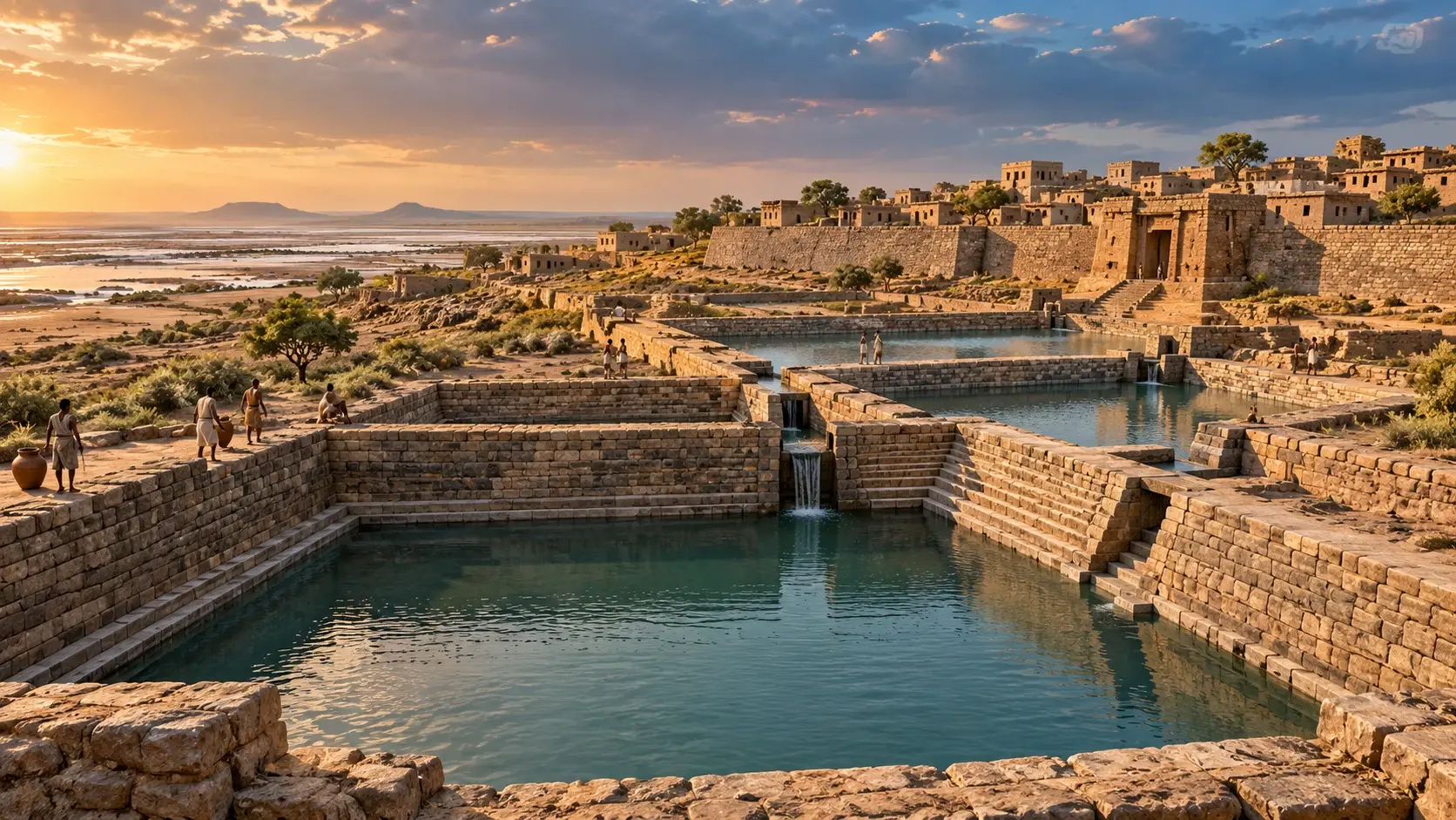
Excavated rock-cut reservoirs, masonry bunds, and monumental stone stairways at Dholavira on Khadir Bet in the Great Rann of Kutch.Archaeological Archives
High in eastern Turkey’s Tendürek Mountains, a 515-foot boat-shaped formation has puzzled researchers for 65 years. In September 2026, university archaeologists began direct core drilling for the first time since 1988. Discover what was actually recovered, how Collins and Fasold exposed early claims, and the falsifiable test awaiting 2027 lab results.
Atop the sacred Sivagiri hill in Palani, Tamil Nadu, stands an ancient idol crafted not from stone or bronze, but from Navapashanam—an alchemical matrix of nine deadly poisons solidified by Sage Bogar. Discover the hidden chemistry, the healing powers of the overnight sandal paste and abhishekam prasadam, the subterranean tunnel connecting Bogar's samadhi, and the controversial 2004 replacement that triggered an international antiquities investigation.
Coorg's hillside resorts book out months in advance now. Gokarna's main beach can feel more like a queue than a shoreline, and Hampi comes with tour buses in equal measure. But Karnataka's Malnad hill country and coastal belt hold a genuinely different kind of trip: rainforest instead of resort, empty tide lines instead of beach shacks, and moss-draped forts you'll have mostly to yourself. Discover 7 secret places in Karnataka that redefine South Indian travel.
Whether you crave snowy Himalayan walks, candlelit palace reflections across Lake Pichola, high-energy beach parties in Goa, colonial carnival effigies in Fort Kochi, or tropical isolation in the Andamans, India offers an astonishing spectrum of year-end celebrations. Discover five magical destinations to spend Christmas and New Year.
In the middle of the arid landscape of Gujarat's Khadir Bet, surrounded by the salt flats of the Great Rann of Kutch, the ruins of an extraordinary Bronze Age city reveal an ancient solution to one of humanity's oldest problems: How do you build a large city where water cannot be taken for granted?
The answer at Dholavira was not a single well, tank or canal. It was an entire urban system. Reservoirs, dams, channels, wells, drainage structures and carefully planned streets were integrated into the city's architecture to capture and conserve seasonal water. UNESCO recognizes Dholavira as an exceptional example of Harappan urban planning, specifically highlighting its sophisticated water reservoirs and drainage system.
The city was occupied for roughly 1,500 years, from around 3000 to 1500 BCE, making it one of the best-preserved urban settlements of the Harappan civilisation. Dholavira's importance therefore extends beyond the question of whether its inhabitants possessed “advanced technology.” The more interesting question is how they adapted an entire city to environmental scarcity.
A Harappan City in an Unforgiving Landscape
Unlike many major Harappan settlements located in riverine environments, Dholavira was established on the arid island-like landform of Khadir in the Great Rann of Kutch. The region receives limited and highly variable rainfall, and the nearby watercourses are seasonal rather than perennial.
Two important seasonal streams, the Mansar and Manhar, flowed near the settlement. These streams became central to the city's water-harvesting strategy. This created a fundamental engineering challenge: rainfall could arrive intensely during the monsoon, but there was no guarantee that water would remain available throughout the dry season. The Harappans therefore had to solve two problems simultaneously: capture water when it was available—and preserve it after the rains disappeared. Dholavira's entire urban design appears to have evolved around that requirement.
Dholavira Was Planned Around Water
The city's architecture was highly organized. The walled settlement included a fortified Castle or Citadel, a Middle Town, a Lower Town and a ceremonial area. Reservoirs were positioned particularly around the eastern and southern sides of the citadel and along other portions of the settlement.
Sixteen or More Reservoirs: Distributed Storage
The most spectacular feature of Dholavira's hydraulic system is its network of at least 16 reservoirs, with excavated evidence indicating additional water-storage structures. These reservoirs varied enormously in size and construction: some were constructed or enlarged by cutting into the underlying rock, while others used embankments, masonry and carefully engineered boundaries.
Several large reservoirs reached depths of approximately 7 metres, while the enormous eastern reservoir measured roughly 73–74 metres in length and about 28–29 metres in width. The reservoirs were not all identical; they formed a network adapted to the site's topography. Dholavira's engineers were not simply building the same tank repeatedly—they were creating a distributed water-storage system.
Dholavira Hydraulic Infrastructure Specifications
Total Documented Reservoirs
At least 16 major reservoirs encircling the Citadel and urban core
Maximum Reservoir Depth
Up to 7 metres, with stepped descents and lowered quarry floors
Eastern Reservoir Dimensions
Approx. 73.5m length × 29m width with monumental stone staircases
Natural Elevation Fall
Approx. 13-metre hydraulic gradient across the city from northeast to southwest
Excavated Well Depth
Up to 13.6 metres deep, stone-lined and linked to internal stone troughs
One of Dholavira's greatest advantages was something modern engineers might call a natural hydraulic gradient. The settlement occupied terrain with a significant elevation difference—approximately 13 metres across parts of the city. The Harappans exploited this slope when arranging reservoirs and water channels. Instead of fighting gravity, they used it.
Water collected at a higher elevation could move toward lower reservoirs. This meant that the city did not require mechanical pumps to move water from one part of the system to another. The basic principle was beautifully simple: *Let the landscape do the work.* The technology was not based on enormous mechanical machines; it was based on understanding terrain, rainfall, gravity and storage.
The Cascading Reservoir System
The term “cascading reservoirs” is useful for describing the way some of the water-storage structures appear to have taken advantage of the site's natural slope. As water moved through the system, higher reservoirs could feed lower areas. The arrangement also allowed the city to divide water storage across multiple structures rather than depending upon one enormous tank.
Excavation evidence indicates that reservoirs were separated by substantial bunds made from earth, mudbrick and stone, with some of these structures also serving as movement routes through the settlement. The system therefore combined several functions: **storage + movement + flood management + urban circulation**. Dholavira's reservoirs were not simply holes dug into the ground; they were components of an integrated urban hydraulic network.
Capturing the Monsoon: Dams on the Mansar and Manhar
The Mansar and Manhar were seasonal streams. During periods of rainfall, water could move rapidly through their channels. The Harappans constructed dams and diversion structures associated with these streams, allowing seasonal runoff to be redirected toward storage areas. Archaeological research associated with R. S. Bisht's excavations records multiple dam structures along both streams.
Reservoirs Cut Into Living Rock
Some of Dholavira's reservoirs were particularly impressive because they were partly or substantially excavated into the underlying rock. The largest eastern reservoir, for example, incorporated rock-cut construction and had multiple stairways descending toward the lower levels. Archaeological descriptions indicate that parts of its floor were deliberately lowered to increase storage capacity.
The labour involved was monumental: the builders were not simply constructing a masonry tank above ground—they were modifying the landscape itself. Bedrock had to be quarried and dressed, masonry embankments erected, stepped descents crafted, and intake apertures aligned with the surrounding city slopes. And all of it had to operate together as a cohesive hydraulic organism.
A Giant Reservoir Beside the Citadel
One of the largest known reservoirs at Dholavira was located near the citadel. It measured roughly 73.5 metres by 29 metres, with a depth of around 7 metres. Multiple stairways provided access to different levels. Its enormous size gives a sense of the scale at which Dholavira's inhabitants were thinking about water storage: this was not merely household water collection, it was municipal-scale water infrastructure.
The reservoir's stairs also reveal an important practical consideration: as water levels fell during the dry season, residents could descend farther into the reservoir to reach the remaining water. The architecture dynamically adapted to changing seasonal water levels.
Wells: A Multi-Tiered Portfolio of Water Sources
Reservoirs were not the only source of water. Dholavira also contained deep wells, including large stone-lined examples associated with internal water-storage structures. One documented well was excavated to a depth of approximately 13.6 metres, while archaeological interpretation suggests that the water table may have extended considerably deeper.
Some wells were connected through channels or troughs to smaller tanks. This created another layer of redundancy: if stored rainwater declined, groundwater could provide an additional source. The result was not a single water supply, but a robust portfolio of water sources: **seasonal runoff + rock-cut reservoirs + deep groundwater wells + internal distribution tanks**. That redundancy would have been indispensable in an environment chronically vulnerable to monsoon failure.
Stormwater Drains vs. Sewage: An Important Distinction
Dholavira's water engineering extended beyond reservoirs. Its citadel contained a network of stormwater drains. Some of the larger drains were sufficiently large for a person to walk through. They were carefully constructed with smooth floors, dressed-stone side walls, massive capstones and ventilation openings. The city was designed to manage water even when it arrived in large quantities: the objective was not simply storing water, but controlling water when too much arrived at once.
Water and the City's Fortifications
One of Dholavira's most interesting characteristics is the way hydraulic infrastructure interacted with the city's defensive architecture. Reservoirs were positioned along the city's margins, and embankments and masonry structures formed part of the broader urban landscape. UNESCO specifically highlights the integration of water reservoirs, drainage, fortifications and planned urban areas as part of Dholavira's outstanding architectural significance.
This means the boundary between water infrastructure and urban defensive architecture was not always separate. A massive stone bund or embankment could help impound millions of litres of water while simultaneously functioning as a rampart or urban circulation avenue. That is hyper-efficient Bronze Age urban planning.
The Reservoirs Were Not All Simply 'Water Tanks'
Another common mistake is to imagine every reservoir as an identical drinking-water tank. The archaeological evidence indicates considerable functional variation: some structures were massive long-term storage reservoirs; others were associated with wells or smaller distribution basins; some featured descending stairways; some were carved directly into rock; others relied heavily on masonry bunds. One excavated tank within the citadel has been interpreted as potentially having a ritual bathing function, indicating that Dholavira's water architecture served diverse civic, domestic, and ceremonial purposes.
How Much of Dholavira Was Devoted to Water?
Popular accounts often say that one-third of the city was devoted to water management. The figure has a basis in archaeological calculations, but the denominator matters: R. S. Bisht's excavation-based work has been cited as estimating approximately 17 hectares of reservoir area—around 36% of the walled area. However, another hydrological study calculates the major reservoirs at roughly 10% of the city's total area, reflecting different definitions of the urban boundary and which water structures are counted.
Therefore, the safest and most rigorous statement is: *Reservoirs occupied a remarkably large share of Dholavira's walled urban landscape, with excavation-based estimates reaching roughly one-third of the enclosed area.* That preserves the true scale of the feat without presenting a contested metric as an absolute certainty.
Could Dholavira Really Have Supported 20,000 People?
Population estimates for ancient cities are inherently uncertain. The often-repeated figure of around 20,000 inhabitants should therefore be presented as an estimate rather than an established census count. The archaeological evidence does demonstrate that Dholavira was a substantial urban centre—UNESCO identifies it as one of the largest and best-preserved Harappan urban settlements and notes that it flourished for approximately 1,500 years. A defensible formulation is: *Dholavira was a large urban centre capable of supporting a substantial population in an exceptionally water-stressed environment.*
Why Dholavira's Water System Was So Resilient
The strength of the system came from redundancy. There was no single component on which the entire city depended: if one reservoir became depleted, others remained available; if rainfall was insufficient, groundwater wells provided backup; if intense monsoon runoff arrived, drains and diversion structures controlled the flood; and as water moved downhill, gravity carried it between tiers without mechanical power.
“A resilient system does not depend on a single source or a single point of failure. Dholavira’s water network embodied this principle 4,500 years ago.”
Beyond Bharat Editorial Analysis — Principles of Ancient Hydraulic Urbanism
Did the Harappans 'Recycle' Wastewater?
This claim should be treated cautiously. There is no strong archaeological basis for saying that Dholavira operated a sophisticated system in which household greywater was systematically recycled for agriculture and gardening. The excavated stormwater drains were generally separate from household wastewater during the main phases described by Bisht. That does not make Dholavira's water management less impressive—quite the opposite. It demonstrates that the Harappans distinguished between rainwater collection and sanitary waste disposal rather than mixing them.
Dholavira and the Broader Harappan Achievement
Dholavira should not be isolated from the broader technological achievements of the Harappan civilisation. Harappan settlements were known for standardized construction, urban planning, drainage, wells, craft production, long-distance trade, standardized weights and measures, and sophisticated civic infrastructure. Dholavira adds an especially clear example of water adaptation in an arid environment: UNESCO recognizes the city not only for water management but also for its urban planning, construction techniques, manufacturing, trade and social organization.
Chronology of Dholavira: 1,500 Years on Khadir Bet
c. 3000–2600 BCE
Stage I–III: Pre-to-Early Harappan Settlement
Establishment of the stone fortress on Khadir Bet, initial damming of the Mansar and Manhar streams, and early reservoir excavation.
c. 2600–2000 BCE
Stage IV: Mature Harappan Urban Zenith
Construction of the integrated 16-reservoir network, monumental stone-cut eastern reservoir, stormwater tunnel systems, and formal citadel planning.
c. 2000–1800 BCE
Stage V: Intermediate Phase
Urban continuity with gradual architectural modifications, maintenance of major hydraulic structures alongside shifting trade networks.
c. 1800–1500 BCE
Stage VI–VII: Late Harappan & Desertion
Decline in civic maintenance, shrinking of inhabited area, climatic aridification in Kutch, and eventual abandonment.
1967–1990s CE
Modern Archaeological Discovery
Identified by J. P. Joshi in 1967–68; extensively excavated by R. S. Bisht of the Archaeological Survey of India (ASI) from 1990 onwards.
Archaeological Evidence vs. Modern Misconceptions
Excavated Archaeological Reality
Drainage Function:Dedicated fresh stormwater drainage and flood control channels with silt vents.
Reservoir Area:Occupied a remarkably large share of the walled area (estimates range 10% to 36%).
Water Sources:Multi-tiered portfolio: seasonal stream dams, rock-cut reservoirs, and deep wells.
Hydraulic Power:Exploited the natural 13-metre terrain slope to direct water flow via gravity alone.
Unsubstantiated Modern Claims
Drainage Function:Claiming a modern-style centralized sewage recycling network existed.
Reservoir Area:Asserting a definitive 'exactly 33.3% of the city was water' as settled fact.
Water Sources:Assuming reliance on a mythical perennial river that dried up overnight.
Hydraulic Power:Hypothesizing lost mechanical pumping engines or electric conduits.
What Eventually Happened to Dholavira?
Dholavira's long history did not end because one reservoir suddenly failed. The settlement underwent multiple phases of transformation over approximately 1,500 years. UNESCO describes a long sequence from early Harappan occupation through mature and later phases, followed by decline and changes in the character of settlement. Environmental changes, shifts in monsoon patterns, changing river systems and broader socioeconomic transformations within the Harappan world all contributed to the city's eventual decline. The city survived environmental challenges for centuries precisely because its inhabitants repeatedly adapted their infrastructure.
Dholavira's Modern Lesson
Today, cities around the world face increasingly difficult questions about water security: rainfall is becoming more variable, urban surfaces accelerate runoff, groundwater is being depleted, and modern planners frequently separate water supply from urban design. Dholavira offers a different conceptual model: its ancient engineers treated water collection, storage, drainage, topography and urban planning as parts of the same system. Water resilience begins with designing the city around the way water actually moves through the landscape.
Conclusion: A City Built Around Water
Dholavira stands as one of the clearest surviving examples of how the Harappan civilisation adapted urban life to a challenging environment. Its 16 or more reservoirs, seasonal-stream diversion structures, wells, channels and stormwater drains reveal an extraordinary commitment to capturing and conserving water. The system was not based on one miraculous invention—it was based on a network. Rain became runoff. Runoff became stored water. Gravity became a transport mechanism. Rock became a reservoir. Seasonal streams became sources of supply. And the city's architecture became part of the hydraulic system. More than four thousand years later, the ruins of Dholavira leave behind a remarkably modern lesson: *The most resilient cities are not those that conquer their environment, but those that understand it.*
Scholarly Frequently Asked Questions
Where did Dholavira get its water in the arid Rann of Kutch?▼
Dholavira relied on a multi-tiered hydraulic system that captured flash monsoon runoff from two seasonal streams (the Mansar and Manhar) via stone dams and diversion channels, storing the water in at least 16 rock-cut and masonry reservoirs, supplemented by deep stone-lined groundwater wells.
Did Dholavira possess a centralized sewage system like Mohenjo-daro?▼
No. Unlike Mohenjo-daro and Harappa, Dholavira's monumental underground stone drains were dedicated to freshwater stormwater harvesting and flood control. Household waste was managed through separate soak jars and local stone installations rather than an integrated municipal sewage network.
How large was the reservoir system at Dholavira?▼
The city featured at least 16 major reservoirs encircling the Citadel and urban sectors. The largest eastern reservoir measured roughly 73.5m in length, 29m in width, and up to 7m in depth, featuring multiple descending stone staircases to access declining water levels.
How did Dholavira move water without mechanical pumps?▼
Dholavira's urban planners exploited a natural 13-metre elevation gradient across the site. By positioning primary diversion channels and intake reservoirs at higher elevations, gravity alone directed excess water downhill into interconnected lower cascading reservoirs.